
Yes, as i wrote above i generated for testing reasons a map of my complete explorations on the medieval realms server. I ended up with a png file of 1.9 GBytes - and i found no application that was capable to open it.

MapViewer - not a plugin but a standalone tool
-
-
here someone could make a little video of, so everyone sees what this tool can do. a video tutorial is for many, if it does not work with the language, a good way.

-
well, I try one export on widest zoom : it shows 6 squares biomes, the image is a 20480x12288 pixel and weight 205mo. a whole big map would be difficult to manipulate I think ?
Well, I tried to make the map viewer as large as possible that it bothers me how the map is the same size as the one in game... Well, not exactly, but similar with how "sectioned" it is that it kinda defeats the purpose. Whatever resolution you have the java viewer is what you get out of the map that whatever you see is what you render. I don't know how the java side handles, but it is a nice out-of-game tool. It's handy, yet needs to render it whole. I can wait out however long it needs to render a whole map.
I want to be 100% clear that I'm not trying to ruin anything. Not trying to knock on the guy who created the tool that I do find it awesome that we can now view maps outside of the game to then share it in .png manner. That's awesome
 I respect you guys for finally tackling something we all wished for. More power to you guys!
I'm used to (spoiled) messing around with various Minecraft map viewing tools that I miss the Isometric tool I used to map out my Minecraft worlds. Same with the Google Map variations where it would render the whole explored map side of things. Whatever you explored it would render it whole. I wish we could get that for Rising World so we could see what we have, how to expand, among other things. I do hope it's possible, and if not we'll wait for when Rising World gains the awesome terrain generator upgrade update.
I'll try and use the current tool to the limit until something else is done. Again, no ill will to the map creator. Awesome stuff that I'll view it as a necessary baby steps. Keep it up!
-

I can wait out however long it needs to render a whole map.
It's not the rendering time that's the issue. The application can render the whole map. The problem is there are no viewers that can open up such a large file that the application generates. This is why the in-game map, as well as every map application out there (including Google Maps and Bing Maps) use separate images and stitch them together as your scroll around the map. A principle called Map Tiles. https://en.wikipedia.org/wiki/Tiled_web_map
There will be a way to process larger maps and compress them into a smaller image, but believe me that process is extremely complex and requires a lot of in-depth knowledge in computer graphics. Looking at each pixel one-by-one and looking at its neighbouring pixels and then generating a new pixel map. And it always results in data loss.
That's the big problem with image compression.
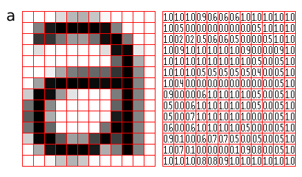
Here's an 'a', its pixels as displayed on a screen, and finally the data structure behind it. If you visit each pixel and analyse its neighbours and recreate a smaller file (to reduce the pixel dimensions from 12x14 to say 6x7) then you actually end up with just a mess of pixels and the "information" (in this case the character 'a') will be lost. Same principle with the maps in Rising World, just on a larger scale.
-
Well, i could try to add an option which saves a scaled down version of the whole map with a dynamic scaling so the max image size is fixed. I‘ll probably need a few days for this - it‘s my spare time after all.
-
Alright, thanks for that yahwho. I actually made note of that with me going into the now "wait and see" mode to see what happens next. I'll see what happens next then play test with whatever happens next. I'll observe. And once again, thanks for the mapping tool

-
Version 0.0.2 - now scaled down output of the complete map possible
Hi all, i added the option to export a png of the complete map, but scaled down dynamically. This means, when you press the command 'm', a map with the following scale will be created:
Dimension in maptiles scale png in pixels up to 80 * 80 1:1 up to 20480*20480 up to 160 * 160 1:2 up to 20480*20480 up to 320 * 320 1:4 up to 20480*20480 up to 640 * 640 1:8 up to 20480*20480 up to 1280 * 1280 1:16 up to 20480*20480 up to 2560 * 2560 1:32 up to 20480*20480 and so on, but i think you won't recognize anything if you go above that size. Even at scale 1:32 is very ambitious to find anything on the map, but for those who have such a big map it is possible to create an image of their world...
Download is here: mapViewer.zip
To install you will need to proceed just as with version 1; if you have already installed version 1 you will need to replace mapviewer-0.0.1.jar with mapviewer-0.0.2.jar. Starting the program is unchanged.
Have fun -
Great job ! A very nice addition for seeing what have been explored. the world is so huge. I thought have did some good explorations and in fact, I have lots of fog war between "roads". The tool have exported a 1:16 map for a 40Mb png.
-
I just downloaded and tried it out, Everything went perfect following the above directions, But once i clicked on a map to open all i'm getting is a blank white java screen. Did I miss something?
-
I did something wrong
I can not see the map
every map -
You need to have explored some part of your world first while having a map ingame in your inventory. Otherwise you will get a white screen / png
-
- @keitha7373 what do you mean by ‚click on a map‘? The program doesn‘t respond to mouse clicks, it only recognizes a few key presses (as explained above). Can you see a map ingame (by pressing M)? If no, then you need to craft a map first and explore a part of the world. After that you can use my program to view a bigger part of the map on screen or export a png.
I see, the world i was using to try it out i had not yet created a map - my bad. Thanks. Works on Windows 10 perfectly. Nice Work!
-
Tbh i didn't know where to upload it back then either as it is no mod and no plugin and randomly chose the mods section. I will ask red if we can have a new standalone tool section or else a subsection under mods.
-
Same here - i randomly chose Plugins.
But i have no preference where to put it, so lets red51 decide and then move everything to the right place. -
Zoom in is not working...

-
WoW! Great job, man!! It´s amazing. Thanks!
Participate now!
Don’t have an account yet? Create a new account now and be part of our community!